OziAPRS
OziAPRS - is a part of a FULL GIS system that allows moving objects to be tracked in real time and displayed on networked computers.
The software will soon have the ability to contact other OziAPRS stations and track their positions in real time
Содержание
Capabilities
The capabilities of OziAPRS include:
- Display positions in OziExplorer gathered over the Internet
- Distribute GPS positions from GPS units attached to OziExplorer
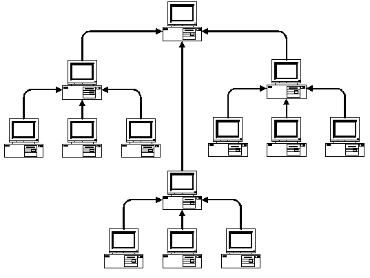
- Operate as a server for other OziAPRS clients to connect creating a GPS position network.
- Downloads APRS positions from APRS compliant internet servers
- Track any internet position as a TRACK in OziExplorer
- Display internet positions in sortable table format.
- Handle MAP files>50MB and zoom from 25% to 800% and a large number of map projections and user calibration points
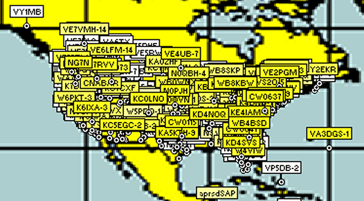
The graphic shown on this page is a screendump of the results of the integration with OziExplorer and OziAPRS.
Eventually we hope to offer full messaging support in this software - although the implementation of that may be delayed due for a number of reasons. One issue is how to move the positioning data around. Radio Modems work well, but this is not within the capabilities of most organisations. But there are other options. GPRS is a good way, ham radio works. SMS works, but is expensive. If you can move data around mobile, then you can use this.
Getting OziAPRS Working
- Install the software
- Start OziExplorer Stat OziAPRS
- Set the Station ID with File|Set Station ID. This is commonly a unique callsign like VK2TDS-1 for instance
- Set the SERVER to connect to with Server|Set Server. This is commonly rotate.aprs.net.au:10151 for testing (You may want to check that you can telnet out by running TELNET ROTATE.APRS.NET.AU 10151 from the command prompt of windows
- Connect to the SERVER with Server|Connect to Server
- If you are running your own network
- Dont set the connect under server YET.
- On the computer running as your HUB, select HUB|Listening
- Dont forget to enable NMEA on this computer
- Telnet into port 7000 of this computer and make sure data is coming out.
- On the computers that connect to this computer, set them up to connect to this computers IP address on port 7000 - for instance 192.168.1.1:7000.
- On the clients Select Server|Connect and also enable NMEA
3 Positions should appear on other computers on the network
Distributed Positioning for OziExplorer
To Do
- Add Wx on Table
- I will look at adding wildcard filters for incoming data - such as auto monitor only. Or for wildcard ignore
- Make TCP server re-entrant
- Add the ability to add Wx information by hand
- Add the ability to click on a stationto view the current data.
- Add messaging
- Add beaconing
- Internet unstable connections
- Add RDF
- Auto-Reconnect on Internet streams
- Status of incoming internet stream
- Document about the moving map functions.
- Add the capability for multiple tracking.
- Change colour of waypoints on how old etc.
- Fix Save Waypoints message
- Add the ability to read UI-View style TNC config files
- TCP/IP Keep Connected
Done - Stuff that was on the Todo list (May not be online yet)
- GPRS/IMEI Telnet in on server Import UIView Overlay Files - Andrew McDade
- Save Tracked Callsigns
- Server for NetGPS
- Add popup for details on particular stations
- Add Time.Date to upload to OziExplorer
- Add weather decode
- Access Integration
- Add uploaded time to description in Ozi
- Cache positions for server connect
- Login to APRS server
- Fixed the reporting of packet line for GOOD packets
- Record if the positions are outside of the limits, or not being uploaded to OziExplorer
- Added GPGLL decoding
- Added the ability to log into a server
- Added the ability to send a filter command on connect
- No use decoding stand along Wx yet as there is no way to send it to Ozi
- Identify unrecognised packets
- Log File: Simply the raw packets in a text file is all that would be needed, possibly marking those that OziAPRS uses with one character, and discarded ones with another, unless a separate character were devised to indicate why discarded packets weren't used, like DUPE, FORMAT ERROR, and OTHER (MSG, BUL, WX, ...). The log filename and location could be fixed (/OziAPRS.log), so the user renames one file if it needs to be retained.
- Add Access database integration
- I am working on getting all positions from UI-View to upload to OziAPRS
- Add sort on Time.Date
- Geographical filtering
- Added a column on the table saying where the data came from
- Added some support for Microsoft Access
- I have added a statistics page under the help menu. This shows the number of packets processed and the number without errors. The number without errors may seem low, but not all packet types are being decoded such as messages.
- The version of the software can now be obtained from the Help About menu, or RightClick Properties on the executable from windows explorer.
- The position errors have been fixed as far as I can tell.
- The problem with 1000 waypoints in Oziexplorer has been worked arround. Now when more than 1000 positions comes in, new stations will not be uploaded to OziExplorer. The exception to this is if 'monitor only selected stations' is set.
- You may plug a TNC-2 into COM1 with 9600 8N1 and have the data seen by the software. No other speeds or COM Ports are supported yet
- Downloads position data direct from UI-View, allowing UI-VIEW to be used to manage the connection to the TNC, or the connection to the Internet. Any positions that UI-View sees will be sent to OziExplorer, and any TCP/IP connections.
- The ability to select which stations are displayed on the map. If you do not wish all stations to appear, select Monitor|Upload Only Selected Stations, and then select the stations you wish to monitor.
- If you wish to add a waypoint, start the program as normal, and double click on OziExplorer on the map. A dialog will appear asking you to enter a callsign. Enter the data, and then the information will appear in OziExplorer, in the OziAPRS table and sent out onto the net.
- You can now double click to move a waypoint too... Bit it will only move if it can be uploaded according to the rules - that is if you have selected monitor only selected packets, the object will move for other users, but not for you, since it should not be on your screen anyway.
- The frame now automatically moves to the bottom of your screen.
- For testing the server aprs.net.au:10153 works well without providing too much data
Bugs
- warning not to sort waypoints in OziExplorer while OziAPRS is accumulating waypoints.
- Sometimes the connection to the server takes a little while to disconnect
- If there is an error connecting to a server no error is reported
Fixed
- Some positions are appearing in the incorrect location. This is a bug with the library and will and will be fixed asap. Fixed 20/Feb/03
- All Stations were being notified as WX stations even if they are not. Fixed 27/2/03
- Fixed an issue with COM port always going to COM4 27/Feb/03